Grahams Bush, Organ Pipes, Buttars Peak, Mt Cargill – Information and Trips Library

Scope:

This page of club tramps and hikes in the West Harbour area groups together trips to Grahams Bush,(map) the Organ Pipes, Buttars Peak and Mt Cargill.

Background Information:

Road distances from Mosgiel carpark.

TRTC Grading Information – trips incorporating these tracks are generally given a TRTC grading of 4. This is indicative only, as trips can be allocated a higher or lesser grading depending on the route taken. For more detailed analysis refer to Grading Information.

Restrictions: if visiting Mt Cutten Quarry site – contact Blackhead Quarries (refer Permissions) to ensure no heavy machinery is operating when visiting.

Grahams Bush Botanical Information (1988) (from DoC information sheet).
Mt Cargill – Information (from DoC information sheet).

How To Get There:

Take SH88 to Port Chalmers. At Sawyers Bay turn left onto Station Road and continue on this road through the roundabout and onto Hall Road. At the end of Hall Road there is a sign indicating the track  and an area for limited  parking.

Links to tramps and hikes in the same area:

24/06/2026. Graham’s Bush/Mt Cargill Rd Quarry Track. Grade 4. Trampers.  Leaders: John Gardiner & Alison Evans.
27/05/2026. Grahams Bush and Organ Pipes. Grade 3.5. Hikers.  Leaders: Mike Webb and Bruce Spittle.
25/06/2025. Grahams Bush, Organ Pipes, Buttars Peak. Grade 4. Trampers.  Leaders: Phil Morris, Rod Ward.
09/10/2024. Graham’s Bush to Mt Cargill.  Grade 4. Trampers.  Leaders: Karen McInnes and Gail Williams

Grahams Bush, Old Main Rd, Organ Pipes, Buttars Peak, Mt Cargill, Mt Cutten, Bethunes Gully, Upper Junction  (2024 – 1989, 18 trips with 11 reports).
Grahams Bush, Upper Junction, Brickhill Rd (2014 – 1993, 15 trips with 4 reports).
Grahams Bush, Careys Bay (2004, 1 trip, no report).
From Old Mount Cargill Road Lookout (1992, 1 trip, no report)
Concord – Information and Trips Library

Scope:

This page of club tramps and hikes in the Dunedin Central City area groups together trips within the suburb of Concord and environs.

Background Information:

Road distances from Mosgiel carpark.

TRTC Grading Information – trips incorporating these tracks are generally given a TRTC grading of about 2. This is indicative only, as trips can be allocated a higher or lesser grading depending on the route taken. For more detailed analysis refer to Grading Information.

See also Tunnel Beach – Information and Trips Archive for Tunnel Beach trips starting at Concord.

Links to tramps and hikes in the same area:

17/07/2024. Concord Creations. Grade 2. Hikers.  Leaders: Jan Butcher.  &  Jenny Finnerty.

Concord Blackhead (1989 – 2015 (4 trips with only 1 report)).

Tunnels, McRaes, Racemans, Top Weir, Powder Creek, Chalkies – Information and Trips Library

Scope:

This page of club tramps and hikes in the Whare Flat area groups together trips within the Silverstream catchment and includes Racemans, Tunnel Gully, Powder Creek and Chalkies. (map)

Background Information:

Road distances from Mosgiel carpark.

TRTC Grading Information – trips incorporating these tracks are generally given a TRTC grading of 3. This is indicative only, as trips can be allocated a higher or lesser grading depending on the route taken. For more detailed analysis refer to Grading Information.

Racemans Track, Weir, Origins.
Whare Flat School and Surrounds History.

Links to tramps and hikes in this area:

08/10/2025. Raceman’s Track. Grade 2.5. Hikers.  Leaders: Sandra Lawn & Bruce Spittle.
14/05/2025.  Racemans. Grade 3. Hikers.  Leaders: Wendy Langley, Eleanore Ryan.
14/08/2024. Tunnel Gully, McRaes, Racemans, Powder Creek Detour. Grade 3. Trampers.  Leaders: Phil Keene & Gary Mort.
26/06/2024. Whare Flat, Waiora, Schoolhouse, Tunnels Track, McRaes Weir, Racemans. Grade 2.5. Hikers. Leaders: Bruce Spittle,  Adrienne Ensor.

Pump House, Tunnels, McRaes Weir, Racemans, Return (2004 – 2020, 10 trips with 6 reports).
Schoolhouse, Tunnels, McRaes Circuit (1989 – 2019, 9 trips with 6 reports).
Silverstream Water-Race, Racemans, Weir (1992 – 2023, 21 trips with 6 reports).
Tramps Associated with the Whare Flat Schoolhouse (1995 – 2017, 5 trips with 3 reports).
School House, Tunnels, McRaes, Steve Amies, Whare Flat Road Return. 2007 (1 trip with report – no photos)

Rain Days – Information and Trips Library

Background Information:

Road distances from Mosgiel carpark.
Rain Days trips are the ones that are diverted because of bad weather; either  before the day or at the carpark gathering on the day.

Links to rainy days tramps and hikes:

16/09/2026. Ross Creek – Redwoods Circuit (alternative trip due to rain forecast). Trampers.  Leaders: Sandy Webb and Alison Evans.
16/09/2026. Fairfield Circuit (alternative Hike due to rain forecast). Hikers.  Leaders: Raewyn Keene and Cathy Ferguson.
05/08/2026. Memorial Park to Confluence of the Silverstream and Taieri River. Grade 2. Combined.  Leaders: Barbara Shackell and Sandy Lawn.
03/12/2025. Trip Cancelled (Brighton Cafe). Hikers.  Leaders: Neville Griffith and Rhonda Wilson.
31/07/2024.  Mosgiel Ramble. Hikers.  Leaders: Ady Whiston, Jenny Finnerty

Ross Creek and Environs (1990-2024 with 34 reports – see 6/10/2021 for rainy day trip))
A cancelled Tramp Day (2018 – 2023 with 2 reports)
Topiary Trek (2015 with 1 report)

Tramps Associated with Whare Flat School House (1995- 2017 with 30 reports – see 15/06/2011 for rainy day trip)

St Clair, St Kilda, Caversham, Kew, Corstorphine, Ocean Grove, Tomahawk – Information and Trips Library

Scope:

This page of club tramps and hikes in the Dunedin Central City area groups together trips incorporating suburbs Caversham, Kew, Corstorphine and Dunedin beaches at St Clair, St Kilda, Tomahawk / Ocean Grove.

Background Information:

Road distances from Mosgiel carpark.

TRTC Grading Information – trips incorporating these tracks are generally given a TRTC grading of about 1.This is indicative only, as trips can be allocated a higher or lesser grading depending on the route taken. For more detailed analysis refer to Grading Information.

Ocean Grove, also known as Tomahawk, is a suburb in the southeast of the city of Dunedin. … The suburb was known as Tomahawk until the 1930s, the name not being a reference to the weapon, but rather possibly an anglicised form of the Māori words tomo haka, meaning “dance by a gravesite”.

Links to tramps and hikes in the same area:

19/11/2025. Out & About in Caversham and Kew. Hikers. Grade 2  $5  14km. Leaders: Jenny Finnerty, Jay Devlin, Jan Butcher, Pam Clough.
12/11/2025. Second Beach to Ocean Grove. Grade 3. Hikers.  Leaders: Sandra Lawn and Bruce Spittle.
26/03/2025. St Kilda / Tomahawk Beach. Grade 1.5 Hikers.  Leaders: Wendy Langley  and Val Cayford.
07/08/2024. City to Surf. Grade2 . Combined. Leaders: Gail Williams, Karen McInnes, Jenni and Bruce Wright.
24/07/2024. Delights of St Clair.  Grade 1.5. Hikers.  Leaders: Neville Griffiths, Wyn Davies.

Caversham – Street Walk. 2023-1999 (5 trips, 3 with reports and photos, 2 with no report or photos)
St Clair Beach Walks (1995 – 2023, 17 trips).
Street Walk: St Clair – Kew (2000 – 2022, 2 trips – 1 report).
Tomahawk Lagoon and Nearby Tracks and Areas (1989 – 2023, 43 trips, 19 reports; see 40, 38, 36, 35, 33, 29 and 26.)

Macandrew Bay, Company Bay, MacTaggart St, Camp Road, Boulder Beach, Pukehiki, Greenacres St – Information and Trips Library

Scope:

This page of club tramps and hikes on the Otago Peninsula groups together trips incorporating Macandrew Bay, Company Bay, Camp Road, Greenacres St, McTaggart St, and Pukehiki. (map)

Background Information:

Road distances from Mosgiel carpark.
MacTaggart St track closed for lambing September and October.

TRTC Grading Information – trips incorporating these tracks are generally given a TRTC grading of about 3. This is indicative only, as trips can be allocated a higher or lesser grading depending on the route taken. For more detailed analysis refer to Grading Information.

Restrictions: Lambing Sept – Nov.

How To Get There:

(1) Macandrew Bay – Greenacres Track – drive along Portsmouth Drive and turn left over the causeway and follow Portobello Road to Macandrew Bay township – ample parking available in front of playground. Take Greenacres Street to the start / ascent of Greenacres Track.

(2) Company Bay – McTaggart St. – as per above. Park at Macandrew Bay playground and take the cycleway walk to McTaggart St on the right approx 10 minutes from carpark towards Portobello.

(3) Boulder Beach – located off Highcliff Road and can be accessed via Buskins Road track or Paradise Track. Further go to Seal Point Road (right turn) past Pukehiki and right again onto Braidwood Road where a carpark is available before the decent to Boulder Beach.

Links to tramps and hikes in the same area:

29/07/2026. Camp Road and Greenacres. Grade 3. Trampers.  Leaders: Gail Williams and Yan Campbell.
29/04/2026. Macandrew Bay, Company Bay, Camp Road, Pukehiki, Greenacres Track. Grade 3.5. Hikers.  Leaders: Jenni Wright & Jill Dodd.
24/07/2024. Macandrew Bay, Company Bay, McTaggart St, Camp Road, Pukehiki, Greenacres Street. Grade 3. Trampers, Leaders: Yan Campbell, Jenny Flack.

Macandrew Bay, Greenacre Street (1989-2024, 12 trips with 6 reports). Hikers.
Macandrew Bay, Company Bay, McTaggart St, Camp Rd, Pukehiki, Greenacres St (1997 – 2022, 5 trips with 4 reports). Trampers, Hikers, Combined.

City to Surf – Information and Trips Library

Scope:

This page of club tramps and hikes in the Dunedin Central City area groups together trips commencing in the City and culminating at St Clair, St Kilda beaches. It also incorporates trips along from Andersons Bay to the Otago Yacht Club marina.

Background Information:

Road distances from Mosgiel carpark.

TRTC Grading Information – trips incorporating these tracks are generally given a TRTC grading of about 2. This is indicative only, as trips can be allocated a higher or lesser grading depending on the route taken. For more detailed analysis refer to Grading Information.

Links to earlier tramps and hikes in the same area:

07/08/2024. City to Surf. Grade 2. Combined. Leaders: Gail Williams, Karen McInnes, Jenni and Bruce Wright.

Stadium to the Sea  2022 (1 trip with report and photos)
Gardens to Surf 2015-2017 (2 trips with reports, 1 with photos)
Portsmouth Drive to Marina 2013-2017 (3 trips with reports)


Nicols Creek – Information and Trips Library

Scope:

This page of club tramps and hikes to the Leith Valley area and groups together trips to Nicols Creek (map) incorporating the Pineapple Track, Nicols Falls, Moon Track and other tracks on Swampy.

Background and History

Road distances from Mosgiel carpark.

TRTC Grading Information – trips incorporating these tracks are generally given a TRTC grading of 4. This is indicative only, as trips can be allocated a higher or lesser grading depending on the route taken. For more detailed analysis refer to Grading Information.

DCC land. Nicols Creek circuit maintained by Green Hut Track Group.
David Nicol was an early settler and dairy farmer. He reputedly bought land here in the hope that the railway line would be routed north through Leith Valley.
Antony Hamel’s YouTube video showing his exploration of the 5 falls of Nicols Creek.
Neighbours at War Background and photos to the Finnerty Family and their house site on the Moon Track by Nicols Creek.
Swampy ridge track background information.
Pineapple Track for background information.
Pineapple and Flagstaff walk for background information.
Nicols Creek Glow-worms

How To Get There:

Take SH1 north and turn left onto Duke St. Continue on Duke St into Malvern St and onto Leith Valley Road. Continue to the sign indicating the Nicol’s Creek Track and mountain bike track. There is limited parking the track entrance. Parking therefore is often best in Booth Road (left off Malvern St) and then take Islay St (off Booth Road) back to Malvern and Leith Valley Roads to the track.

Links to tramps and hikes to the same area:

27/05/2026. Pineapple Track / Nicols Creek. Grade 4. Trampers.  Leaders: Karen McInnnes and Sarah McCormack
10/09/2025. Nicols Creek, Moon Track, Swampy Ridge, Pineapple and Shortcut Tracks. Grade 4. Trampers.  Leaders: Gwenda Farqharson, Lyn Keene.
26/06/2024. Nicols Creek, Pineapple Track. Grade 4. Trampers. Leaders: Wyn and Ross Davies.

Nicols Creek, Swampy, Pineapple Track, Moon Track, Booth Road 2023 – 1989 (27 trips, 9 with reports and photos, 1 with report only, 17  with no reports or photos)
Bull Ring, Swampy, Nicols, Pineapple Point, Davies, return 2020 – 1989 (4 trips, 2 with reports and photos,
Nicols Creek Bridge, Morrisons Burn, Poleline Road, Swampy, Nicols or Pineapple  2016 – 2006 (6 trips, 2 with reports and photos, 1 with photos only, 3 with no reports or photos)
Nicols Creek, Swampy Saddle, Davies Track  2011 – 2001 (3 trips, 1 with report and photos, 2 with reports only)
Moon, McQuilkan, Possum Hunters, Jim Freeman, Pineapple, Nicols  2008  (1 trip with report and photos)
Nicols Creek, McQuilkans (no reports).
Booth Rd, Nicols Creek, McQuilkan, Jim Freeman, Pineapple. Either direction (no reports)
Leith Valley, Nicols Waterfall, Sullivans Dam (no report)

Big Easy, Signal Hill, Ravensbourne, Opoho, Northern Cemetery – Information and Trips Library

Scope:

This grouping of Club tramps and hikes covers trips involving the Big Easy to Signal Hill Memorial, Ravensbourne, Opoho (incorporating Willowbank), the Northern Cemetery. (map)

Background Information:

Road distances from Mosgiel carpark.

TRTC Grading Information – trips incorporating these tracks are generally given a TRTC grading of 3. This is indicative only, as trips can be allocated a higher or lesser grading depending on the route taken. For more detailed analysis refer to Grading Information.

Town Belt Article – good links to Signal Hill and Green Belt.
Opoho Historical Background Notes

How To Get There:

The Big Easy is one of the cycle tracks that ascends to the Signal Hill lookout. To access this track take SH88 to the Dunedin Stadium. Turn left at the roundabout then right onto Butts Road (by Palmers Quarry). Follow this road to Logan Park High School and turn right on the road just past the school. This road to the carpark and toilets located behind the school.

Links to tramps and hikes in this area:

29/04/2026. Signal Hill from Ravenbourne. Grade 4. Trampers.  Leaders: Sandy Webb & Gail Williams.
26/11/2025. Bid Easy Track. Grade 2.5. Hikers.  Leaders: Barbara Shackell and Avis Williamson
16/10/2024. Ravensbourne, Signal Hill, Big Easy. Grade 3. Trampers.  Leader: John Gardiner.
21/08/2024. Big Easy. Grade 2.5. Hikers. Leaders: Pam Clough, Jay Devlin.

Signal Hill Centennial Memorial, Ravensbourne, Big Easy (2023 – 1998, 24 trips with 9 reports).
Botanic Garden, Logan Park, Northern Cemetery, Chingford, Big Easy (2021 – 1996, 25 trips with 16 reports inc. 19/05/2021 and 30/09/2015 for Big Easy).
Signal Hill Tramps (2023 – 1992, 19 trips  with 8 reports inc. 22/08/2018 for Big Easy).
Street Walk – Willowbank-Opoho area. (2022 – 2017, 2 trips with reports)

Tunnel Beach – Information and Trips Library

Scope:

This page of club tramps and hikes in the Fairfield, Green Island and Mosgiel surrounds area and groups together trips incorporating Tunnel Beach. (map)

Background Information:

Road distances from Mosgiel carpark.

TRTC Grading Information – trips incorporating these tracks are generally given a TRTC grading of about 2. This is indicative only, as trips can be allocated a higher or lesser grading depending on the route taken. For more detailed analysis refer to Grading Information.

Tramping Track managed by DOC. Tunnel Beach Road accessed from Blackhead Road. Plenty of parking at end of Tunnel Beach Road. Concord Tavern park for longer walk.

Tunnel Beach Walkway (general information and history).
Dunedin’s Hills’ History (brief mention of Tunnel Beach geology at the end).

How To Get There:

Take SHI north to the Green Island exit ramp. Proceed through the roundabouts and take a right turn at the exit to Waldronville. Continue on the main road and turn left onto Blackhead Road (before Waldronville), and drive to Tunnel Beach Road located past the quarry on the left to reach the track and parking.

Links to tramps and hikes in the same area:

03/07/ 2024.  Tunnel Beach, Concord Tavern Lunch – Mid Winter Catchup. Combined. Grade 2. Leaders: Phil and Helen Morris, Jay Devlin and Margaret Maxwell.

Tunnel Beach Archive (Hikers, Trampers, Combined)
Midwinter Dinner Occasions (including Tunnel Beach 23/06/2010).

Midwinter Dinners – Information and Trips Library

Scope:

This page groups together the midwinter dinners / lunches hosted by the club. These events are often preceded by a walk and as such are included in the reports / photos relating to the walk that is submitted for publication.

Links to midwinter dinners:

17/06/26. Mid Winter Luncheon – Concord Tavern. Leaders: Committee Members.
02/07/2025. Mid Winter Lunch at Waihola. Grade 2. Combined.  Leaders: Noel McRandle, Dave Roberts, Gwenda Farqharson, Karon Reid.
03/07/ 2024.  Tunnel Beach, Concord Tavern Lunch – Mid Winter Catchup. Combined. Grade 2. Leaders: Phil and Helen Morris, Jay Devlin and Margaret Maxwell.

5 July 2023. 35th Birthday/ Mid winter lunch
Midwinter Dinner Occasions (2010-2020)
Midwinter Street Walk – Street Art (includes Midwinter dinners 2016-2021)
Waihola Walk (2017)

Millennium Track from Taieri Mouth (inc. Livingstone Green Wetlands) – Information and Trips Library

Scope:

This page covers the Club tramps and hikes in the area South Coast and groups together trips to the Millennium Track  located on Lower Taieri River commencing at Taieri Mouth. (map). Incorporating trips to the Livingstone Green Wetlands

Background Information:

Road distances from Mosgiel carpark.

TRTC Grading Information – trips to the Millennium Track are generally given a TRTC grading of 3. This is indicative only, as depending on the track conditions, allocation of gradings can differ from this. For more detailed analysis refer to Grading Information.

Taieri River Geology for some background information.
Legends of the Lower Taieri includes a section about John Bull if you persist in reading down far enough.

How To Get There:

Drive to Brighton and proceed through the township to Taieri Mouth Road that follows the coast road to Taieri Mouth. Crossing the over the bridge turn immediate right onto Riverside Road there is parking and the start of the track at the end of this road.

Livingstone Green Wetlands – turn left after crossing the bridge and continue along Moturata Road to Livingstone Domain (on left) for parking.  Wetlands entrance gate about 100 meters back down Moturata Road.

Links to tramps and hikes in this area:

09/09/2026.  Millennium Track to John Bull Creek Return and Livingstone Green Wetlands. Grade 3. Trampers.  Leaders: Phil Morris, Clare Banks.
03/12/2025. Millennium Track from Taieri Mouth to Lookout. Grade 3. Trampers.  Leaders: Sandy Webb and Alison Evans.
23/04/2025. Taieri Mouth/Millennium Track. Grade 3. Hikers.  Leaders: Linda Partridge & Bill Cubitt.

John Bull Gully Track and Millennium – from Henley and Taieri Mouth (1993 – 2016, 17 trips with 6 reports).
Taieri Mouth – Inc Millennium, Moturata Island, Akatore, Alanton Block (1989 – 2023, 15 trips with 13 reports including 29/03/2023 Millennium Track).

Street Art Walks Dunedin – Information and Trips Library

Scope:

This page of club tramps and hikes in the Dunedin Central City area groups together trips focused on viewing the Street Art found on many buildings within the city.

Background Information:

Road distances from Mosgiel carpark.

TRTC Grading Information – trips incorporating these tracks are generally given a TRTC grading of about 3. This is indicative only, as trips can be allocated a higher or lesser grading depending on the route taken. For more detailed analysis refer to Grading Information.

Links to art walks in the same area:  

13/08/2025. South Dunedin Street Art. Grade 1.5. Hikers.  Leaders: Val Crayford and Wendy Langley.
21/08/2024 . Street Art Walk.  Grade 1.5. Trampers Leaders: Wendy Langley, Val Cayford.
10/07/2024. Street Art Trail and Surrounds. Grade 1.5. Hikers. Leaders: Wendy Langley, Val Cayford.

Midwinter Street Walk – Street Art (2015 – 2021)
Follow the Leith (2022 – 2023) University campus.

Racemans, Steve Amies Loop, Coal Creek – Information and Trips Library

Scope:

This page of club tramps and hikes in the Whare Flat area groups together trips within the Silverstream catchment and includes Racemans, Steve Aimes and Coal Creek tracks.  (map)

Background Information:

Road distances from Mosgiel carpark.

TRTC Grading Information – trips incorporating these tracks are generally given a TRTC grading of about 4. This is indicative only, as trips can be allocated a higher or lesser grading depending on the route taken. For more detailed analysis refer to Grading Information.

Racemans Track, Weir, Origins

How To Get There:

Upon leaving Peter Johnston Park, turn left onto Factory Road and follow this until it merges into Dukes Road North. Continue towards Three Mile Hill and  turn left onto Silverstream Valley Road. Continue on this road to the carpark just past Flagstaff Whare Flat Road.

Links to tramps and hikes in this area:

25/03/2026. Whare Flat-Racemans-North Coal Creek-Steve Amies-Return. Grade 4. Trampers. Leaders: Robyn and Martin Hickley.
23/7/2025. Steve Aimes / North Coal Creek. Grade 4. Trampers.  Leaders: Graham Thurlow and Neil Hodgkin.

Racemans, North and Little Coal Creeks, Steve Amies (2020 – 2023, 2 tramps with reports).
Steve Amies and Associated Tracks (2000 – 2018, 19 trips with 12 reports).
Trig Q, Steve Amies Track Tramps (1995 – 2013, 9 trips with 2 reports).
School House, Tunnels, McRaes, Steve Amies, Whare Flat Road Return (2007, 1 trip with report).

Lamb Hill: 3 O’Clock, Fiddlers, Orbells

9. 7/12/2022. Trampers Lamb Hill, Fiddlers Hut, 3 O’clock Stream. Grade 4.5 Leaders: Phil and Gwenda

Thanks again to 15-year managers Chris and Lucy Thomson for allowing us on their farm, split by the stream with an altitude of 180 to 700m above sea level.  These 4550 hectares of steep exposed hill country run, alongside 10,880 ewes, 750 mixed aged Angus cows, including 200 yearlings in-calf heifers, recently scanning 97% in calf. The yearling girls well and truly pay their way going to the bull at 350-390kg LW an impressive feat given Lambhill’s challenging climate. (all other history can be looked up on the internet.)

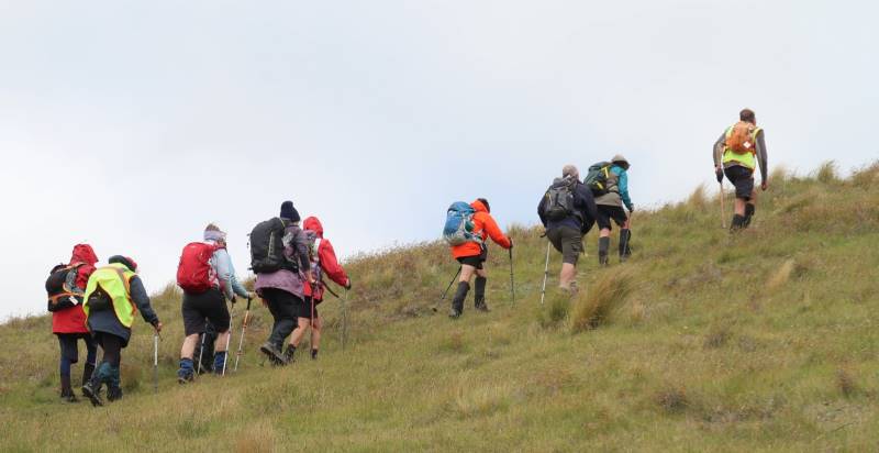
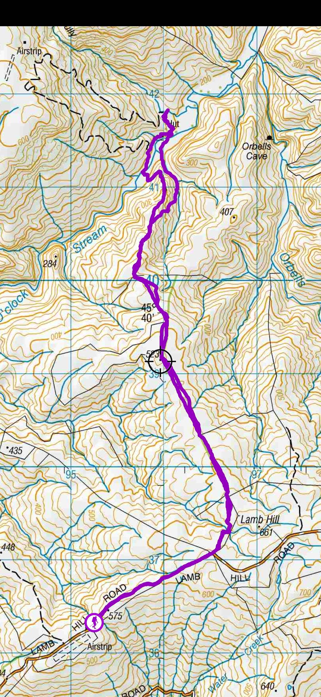
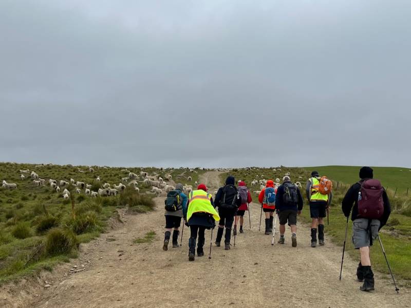
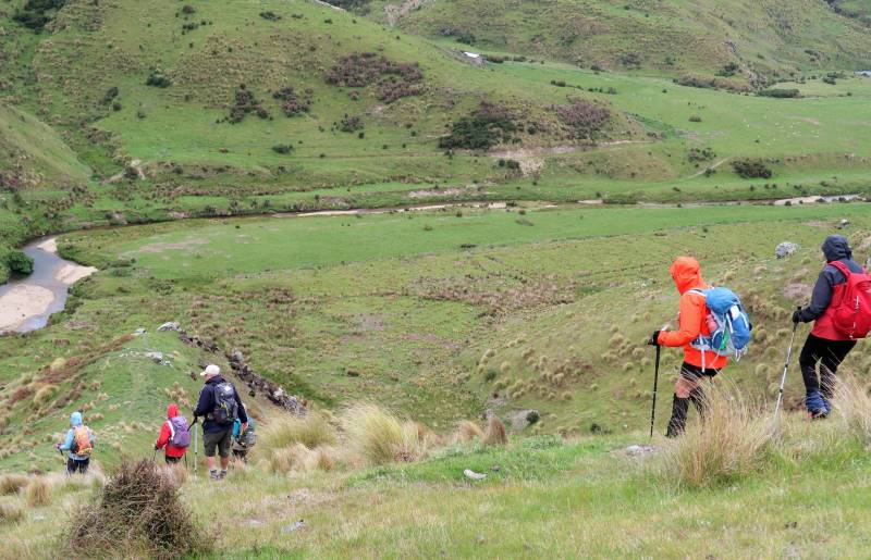
We had 11 hardy trampers battle into a cold NE wind. We worked up from the airstrip a km before heading through the first gate and then headed NW into good terrain of green paddocks. We worked over to what was a tree line now removed, heading off more west beside the Angus cows and calves and then numerous paddocks of sheep with a lot of twin lambs.

Heads down into a cold southerly wind Caption and photo Pam

Lynn did her job of herding a lamb back to her mum. After an hour and a half we arrived at the top of the hill looking down on Fiddlers Hut and 3 O’clock Stream.

Descending to Fiddlers Hut across the stream. Caption and photo Ross

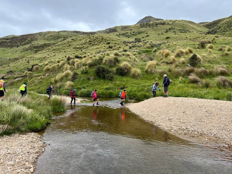
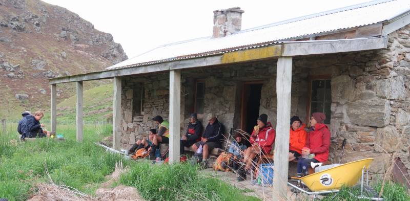
We found a crossing that wasn’t too deep and crossed the stream ready for lunch at hut by 12.44 pm.


“Walking on water”- 3 O’Clock Stream Caption and photo Pam


Lunching at Fiddlers Hut. Caption and photo Ross
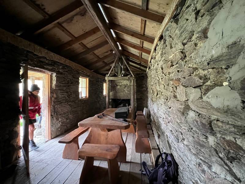
Inside Fiddlers Hut Caption and photo Pam

After lunch, we decided to return around the ridge to the east, 10 minutes in we thought we could hear the squeal of a falcon or its chicks, so we moved as quickly as possible not to disturb.

We could hear the Falcon’s calling in this gully. Caption and photo Pam

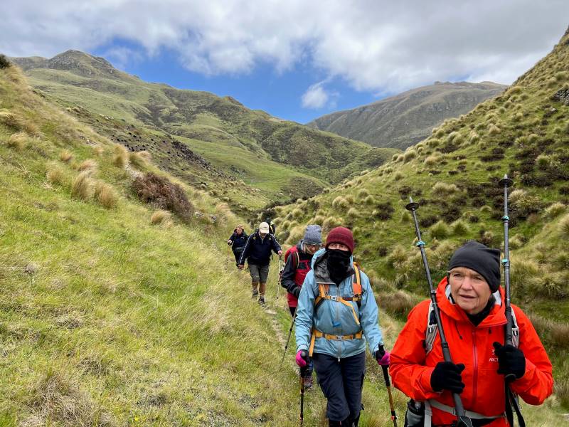
We then needed to head to the top of the ridge so we could work out how to return the way we had arrived. It was hard work and the wind was unforgiving.

Uphill With a Tail Wind - Phil to the fore Caption and photo Ross
Uphill With a Tail Wind – Phil to the fore Caption and photo Ross

So with a few rest stops’ we headed back to the cars. I must admit we were not quite as chirpy as the case on the way down. It was an impressive property but only the hardy would survive the wind. Back to the car, we munched on some chocolate goodies to revive energy.

Hindon must be a lonely spot in winter, but the land has magic not seen that often.

Thanks to tail-end Charlie Gwenda.  Phil

Dist 16.51km  elevation 628m time 4hrs actual walking (ala strava)

16km to Fiddlers Hut Screenshot and caption Sarah

Continue reading “Lamb Hill: 3 O’Clock, Fiddlers, Orbells”